

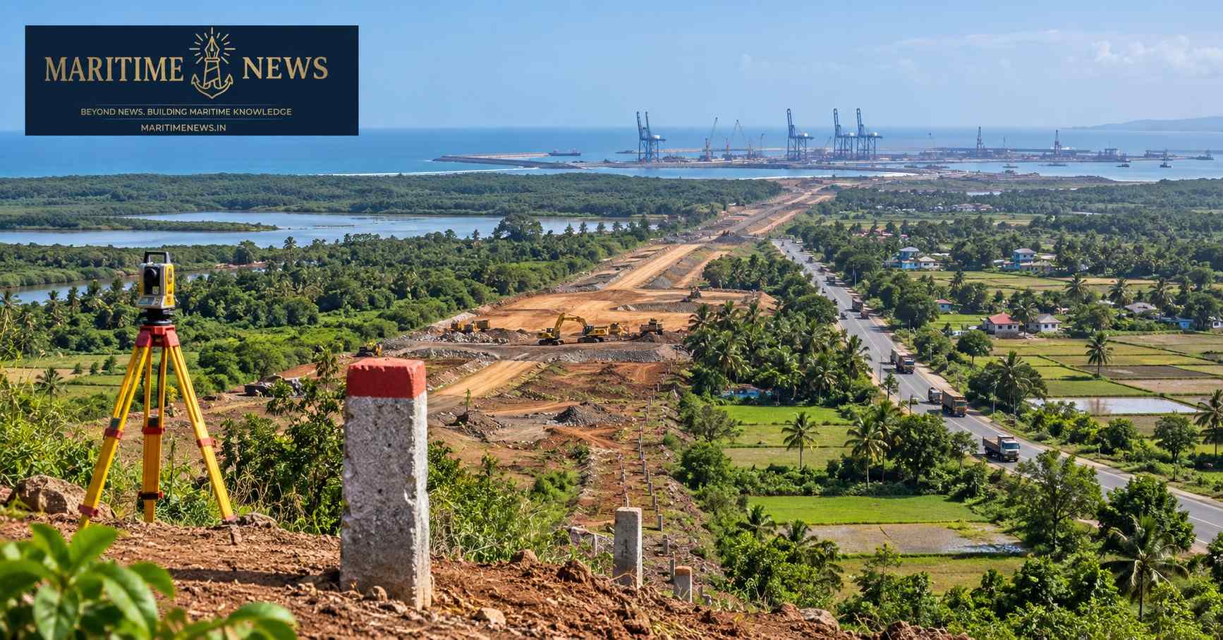
Survey discrepancies, disputed tree compensation, revenue-record gaps and pending court cases are complicating the 32-km Greenfield highway and 22-km service-road corridor needed for the ₹76,220-crore Vadhavan Port project
Make us preferred source on Google
Key Takeaways
- The Greenfield connectivity package includes a 32-km Greenfield highway, while a 22-km service-road component is also being developed within the relevant right-of-way areas.
- Loksatta reports that 484 hectares are to be acquired in Palghar and Dahanu for the Greenfield highway, with proposed compensation of about ₹1,840 crore. (Loksatta)
- Survey and measurement disputes are affecting the identification of the exact land and assets falling within the acquisition area.
- Tree enumeration and compensation have emerged as one of the most sensitive issues, with re-verification facing resistance in some villages. (Loksatta)
- Revenue-record problems involving sub-divisions, inheritance and ownership are adding to the litigation burden.
- The administration says it has undertaken verification, revenue camps and grievance mechanisms and has disbursed substantial compensation. (Free Press Journal)
- 124 landowners in Varor voluntarily handed over about 2.5 hectares across 41 subdivisions, demonstrating that negotiated resolution is possible. (The Economic Times)
- The Bombay High Court has permitted diversion of 9.24 hectares of mangrove forest containing 208 mangroves for the port connectivity highway after considering the applicable clearances and compensatory afforestation measures. (The Indian Express)
- The larger challenge is now to ensure that speed of acquisition does not come at the expense of accuracy, transparency and community confidence.
Also Read: Mumbai Port Showcases Cruise Infrastructure, Marina Plans to Seychelles Parliamentary Delegation
PALGHAR, MAHARASHTRA: The Vadhavan Port project is moving ahead with one of India’s largest planned maritime investments, but the infrastructure needed to connect the proposed port to the hinterland is facing a complex ground-level challenge: land acquisition.
A detailed ground report by Loksatta’s August 17 report on Vadhavan Greenfield highway land acquisition has highlighted disputes involving land boundaries, tree compensation, survey records and pending legal cases in Palghar and Dahanu talukas.
The report comes against a backdrop of contrasting developments. The Palghar administration has maintained that the acquisition process is transparent and that verification mechanisms are in place, while the Maharashtra Chief Minister has said land would not be forcibly acquired. At the same time, local organisations continue to question the consent, compensation, rehabilitation and environmental implications of the project.
The result is a project in which port construction, highway connectivity, land records, compensation, environmental safeguards and community confidence are becoming increasingly interconnected.
Why Connectivity Is Critical to Vadhavan Port
Vadhavan is being developed as a ₹76,220-crore deep-draft greenfield port in Palghar district by Vadhavan Port Project Ltd. (VPPL), a joint venture of the Jawaharlal Nehru Port Authority (JNPA) and Maharashtra Maritime Board (MMB).
The proposed port is intended to substantially expand India’s container-handling capacity and is designed around very large vessels.
But a port of this scale cannot function through marine infrastructure alone.
Cargo arriving at the quay must move efficiently to highways, railways, industrial clusters and the national logistics network.
That makes the Greenfield connectivity corridor a critical part of the port project rather than a secondary road project.
The Bombay High Court, while considering the highway’s mangrove issue, itself described the connectivity project as providing access to Vadhavan Port and noted the project’s public-utility and economic significance. (The Indian Express)
32-Km Highway, 22-Km Service Road and 484 Hectares of Acquisition
According to Loksatta’s August 17 report, a 32-km Greenfield highway is being developed for Vadhavan Port.
Alongside this, approximately 22 km of service roads are being constructed to facilitate movement of minor minerals from the Gargaon-area stone quarries and other construction-related traffic.
Loksatta reports that land acquisition for the Greenfield highway covers approximately 484 hectares across Palghar and Dahanu talukas, with compensation proposed at around ₹1,840 crore. (Loksatta)
In Dahanu taluka, the report said 197 hectares out of 244 hectares had been acquired, representing about 80.61% of the land, while compensation had actually been paid for 99 hectares at the time of its publication. (Loksatta)
This illustrates an important distinction:
Land being identified or measured is not necessarily the same as land for which compensation has been completed and possession secured.
The Survey Problem: Where Does the Acquired Land Actually Begin and End?
The most important issue emerging from the local reporting is not simply whether landowners agree to acquisition.
It is which exact piece of land is legally and physically being acquired.
The Marathi report supplied to MaritimeNews and Loksatta’s subsequent reporting point to differences between:
- physical possession;
- revenue records;
- survey and group numbers;
- sub-divisions;
- satellite mapping;
- village maps; and
- the actual right-of-way being measured on the ground.
The acquisition process requires survey numbers and maps to correspond accurately with the physical alignment.
Where this does not happen, even a small boundary discrepancy can affect:
- land area;
- ownership;
- structures;
- wells;
- trees;
- agricultural assets;
- compensation;
- and ultimately possession.
A November 2025 PTI report carried by Rediff Money showed how detailed the assessment had become. In Varor and Chinchani, officials had completed the main survey and primary land measurement, while landholders were asked to identify boundaries and disclose assets including structures, trees, wells and commercial fisheries before evaluation. (Rediff)
The notice also warned that if landholders did not participate, assessment could be undertaken unilaterally. (Rediff)
Also Read: National Shipping Board’s First Sagar Samvad Starts With “IF”
Why Trees Have Become a Major Flashpoint
The tree issue is particularly important because it sits at the intersection of physical measurement and financial compensation.
Loksatta reported that in Shigaon, a joint site inspection by the land acquisition office, land records officials and the Agriculture Department resulted in a reduction of approximately ₹7.5 crore from the draft compensation amount after verification of the recorded assets. (Loksatta)
The same report said similar re-verification of tree compensation was expected in Bavda, Chinchani and Tanasan in Dahanu taluka.
However, local opposition to the re-verification reportedly complicated the process. (Loksatta)
This creates an unusual administrative dilemma.
If the original tree inventory is disputed, authorities need to verify it.
But if affected residents oppose re-verification, the verification itself can become another point of conflict.
The issue therefore cannot be resolved simply by fixing a monetary rate for each tree.
The administration must first establish:
How many trees were actually standing on the legally acquired parcel at the relevant date, where they were located, who had the legal entitlement to the land, and whether the original inventory accurately captured them.
Revenue Records Are Adding Another Layer
The Marathi ground report also identified problems involving sub-divided holdings, transfers, inheritance and outdated revenue records.
In several locations, the person physically occupying land may not correspond exactly with the person appearing in the revenue record.
Inheritance may not have been recorded.
Sub-divisions may not have been formally measured.
Land may have changed hands without corresponding updates in official records.
For a normal property transaction, these issues may take time to resolve.
For a major infrastructure project requiring continuous right-of-way, they can become a direct construction constraint.
The Palghar administration has acknowledged that family disputes and documentation problems were contributing to delays and said special revenue camps were being conducted to update land records. (Free Press Journal)
Litigation Adds to the Complexity
The Marathi ground report supplied to MaritimeNews said that 20–25% of the land-acquisition cases were reportedly before courts, citing unresolved issues involving sub-divisions, inheritance, ownership and related revenue matters.
This figure should be understood as a reported ground-level assessment rather than an independently verified MaritimeNews statistic.
The legal dimension surrounding Vadhavan is broader than individual acquisition cases.
The Bombay High Court has previously dealt with challenges relating to the environmental approval for the port, and the Indian Express reported that the earlier verdict was under challenge before the Supreme Court. (The Indian Express)
That means the project is progressing within a legal landscape where land, environmental and infrastructure issues overlap.
Change in Acquisition Administration
Loksatta’s August report also highlighted an institutional challenge.
Responsibilities of the competent authorities handling acquisition in Palghar and Dahanu were shifted to the respective Sub-Divisional Officers.
The report noted that these officers already have multiple responsibilities, including revenue administration and hearings on appeals, and that taking over an already complicated port-related acquisition process could make maintaining momentum difficult. (Loksatta)
This is an important implementation issue.
Continuity matters in land acquisition.
Every new officer has to understand the acquisition maps, pending objections, court matters, compensation cases, disputed survey numbers and stakeholder relationships already developed by the previous administration.
A change of officer does not reset the complexity.
Administration’s Position: Verification Before Compensation
The Palghar administration has strongly rejected the suggestion that the acquisition process is being handled without safeguards.
In May 2026, Collector Dr Indu Rani Jakhar said Agriculture and Forest Department officials had been directed to conduct rigorous on-site verification of trees and other assets.
The administration said payments for trees and other such assets had not been released pending verification. (Free Press Journal)
The administration also said land compensation rates had been fixed according to government norms and that landholders dissatisfied with the rates could accept compensation under protest and pursue the prescribed arbitration mechanism. (Free Press Journal)
It reported that approximately ₹240 crore in compensation had been disbursed at that stage and that special revenue camps were being organised to address family and documentation issues. (Free Press Journal)
The administration also introduced a dedicated email channel and specified hours for landholders to approach the Collector regarding grievances. (Free Press Journal)
Also Read: From Adani Ports CEO to Allcargo MD: The Pranav Choudhary
Compensation Process Was Also Changed
In June 2026, the Palghar administration shifted the compensation account associated with the Vadhavan acquisition process from a private-sector bank to Union Bank of India, describing the move as an effort to strengthen transparency, accountability and public confidence. (Deccan Herald)
The change is significant because compensation is one of the most sensitive parts of any large-scale land acquisition exercise.
A technically correct valuation can still generate distrust if landholders do not understand:
- how the valuation was arrived at;
- who is entitled to receive the money;
- how tree and asset compensation was calculated;
- why one parcel receives a different amount from another; and
- how objections can be challenged.
124 Landowners Show That Negotiation Can Unlock Stalled Parcels
There is, however, an important counter-example to the perception that all acquisition is confrontational.
In May 2026, 124 landowners in Varor village voluntarily handed over possession of approximately 2.5 hectares spread across 41 subdivisions after agreeing to government terms. (The Economic Times)
The parcel had reportedly been held up because of complex survey disputes.
According to the district administration, senior officials visited the village and held direct consultations with landowners before the transfer.
The administration described the development as a sign of community confidence. (The Economic Times)
This episode is important because it suggests that direct engagement can resolve even complicated multi-owner parcels when the affected stakeholders believe the process is fair and workable.
At the same time, local groups subsequently disputed the administration’s broader characterisation of the acquisition process as consensual.
Also Read: Mormugao Port: From Iron-Ore Gateway to Multi-Commodity Port
Local Opposition Has Not Disappeared
The voluntary handover should therefore not be interpreted as meaning that community opposition has ended.
Sprouts reported in May that the Vadhavan Port Virodhi Sangharsh Samiti challenged administrative claims regarding consent, ownership, compensation and rehabilitation, arguing that unresolved inheritance and stakeholder-identification issues remained. (Sprouts News)
The report illustrates the continuing difference between the administration’s interpretation of cooperation and the position of some affected groups.
That difference matters.
A landowner agreeing to a particular parcel transfer does not automatically establish community-wide consent for the entire project.
Maharashtra Government’s Position: No Forcible Acquisition
Maharashtra Chief Minister Devendra Fadnavis stated in June that there would be no forcible land acquisition for the Vadhavan Port project.
He said acquisition would proceed through discussions with farmers and the local fishing community. He also said the government wanted the local community to benefit from the project, including through skill development, upgrading the local ITI and development of a separate fishing port. (The Times of India)
The Chief Minister also said major work was targeted for completion within three years and that around 90% of regulatory permissions had been obtained at the time of his statement. (The Times of India)
This puts the land-acquisition process directly into the project’s delivery timeline.
Also Read: From Flood Recovery to Maritime Connectivity: New Assam Development Push Takes Shape
Fisherfolk and Coastal Ecology: The Issue Beyond Landowners
The Vadhavan debate is not limited to agricultural land.
Fishing communities have raised concerns about livelihoods and the wider coastal ecosystem.
A broader report on the project highlighted concerns from farming and fishing communities over potential impacts on livelihoods and the fragile coastal ecology of the Dahanu region, while noting that the project has faced sustained local opposition. (LinkedIn)
This is particularly important because a person whose land is not acquired can still be economically affected by a port project.
A fisher may lose access to a traditional fishing area.
A small trader may depend on local traffic patterns.
A village may experience changes in road access, water availability or agricultural activity.
Therefore, “land acquired” and “livelihood impact resolved” are not necessarily the same thing.
Mangroves Add a Separate Environmental Challenge
The connectivity highway has also entered the judicial and environmental record.
On June 23, 2026, the Bombay High Court allowed NHAI’s plea for diversion of 9.24 hectares of mangrove forest containing 208 mangrove trees for construction of the eight-lane access-controlled highway connecting the proposed port to NH-48. (The Indian Express)
The court noted that the project proponent had obtained environmental, forest and Coastal Regulation Zone clearances and had undertaken compensatory plantation of 1.33 lakh mangroves over 30 hectares, besides depositing more than ₹4.83 crore towards compensatory afforestation. (The Indian Express)
The court considered the highway to be a project of public utility and importance and granted approval for the diversion and felling subject to the applicable conditions. (The Indian Express)
But the environmental debate does not end with the court’s permission.
The question for the project is now whether mitigation and compensatory measures will be implemented, monitored and ecologically effective over the long term.
Also Read: Can Assam Build a Global Export Economy on One of the World’s Most Dynamic Floodplains?
Why the Next Phase Is More Difficult Than the First
The acquisition numbers can improve rapidly once straightforward parcels are settled.
The remaining parcels are often the difficult ones.
They may involve:
- multiple owners;
- inheritance claims;
- disputed boundaries;
- unrecorded sub-divisions;
- trees and other assets;
- government and private ownership overlapping;
- court cases;
- objections to remeasurement;
- environmental restrictions; and
- community organisations questioning the process.
That means the remaining land cannot necessarily be acquired at the same pace as the first tranche.
The last 20% of a corridor can sometimes consume disproportionate administrative effort because it contains the most complicated parcels.
For Vadhavan, that is particularly important because the port’s value depends on continuous connectivity.
The Real Challenge: Building a Continuous Right-of-Way
A mega port can be designed in engineering drawings.
A highway can be approved on a project map.
But construction requires a legally secure and physically identifiable continuous right-of-way.
That requires agreement between:
Survey → Revenue Records → Ownership → Measurement → Asset Inventory → Compensation → Possession → Construction
If any link remains unresolved, the road can encounter a bottleneck.
This is why the present acquisition disputes deserve attention beyond the immediate compensation question.
They are effectively a test of whether the institutions implementing India’s largest new port project can translate a national infrastructure vision into parcel-level execution.
Also Read: India’s Trade Performance Highlights Goods and Markets Requiring Attention
Challenges Ahead
1. Reconciling physical possession with official records
The administration needs a single verified record showing the survey number, ownership, physical boundary and acquired area.
2. Establishing a defensible tree inventory
Trees should be geo-referenced, numbered, photographed and jointly verified before compensation and possession.
3. Resolving inheritance and subdivision cases
Pending mutation and succession cases need time-bound resolution if they are to avoid becoming construction bottlenecks.
4. Maintaining institutional continuity
Frequent changes in competent authorities can slow a process that already involves large volumes of technical and legal information.
5. Maintaining community confidence
The administration’s claim of transparency and local groups’ claims of unresolved consent must be addressed through verifiable parcel-level information.
6. Balancing speed with environmental safeguards
The highway has received judicial approval for the specified mangrove diversion, but the effectiveness of compensatory measures will require continued monitoring.
7. Protecting livelihoods beyond acquired land
Farmers, fisherfolk and other local economic stakeholders need to be assessed not only according to whether their land is acquired, but also according to whether their livelihood is affected.
MaritimeNews Insight
Vadhavan’s Last-Mile Test Is Not the Port — It Is the Confidence Behind the Connectivity
Vadhavan is being presented as a transformation of India’s maritime infrastructure.
But for the people living along its connectivity corridor, the project is experienced very differently.
A survey number is not an abstract administrative entry to a landowner.
A tree count can determine a family’s compensation.
An inheritance entry can determine who receives payment.
A boundary stone can determine which part of a property is acquired.
A fishing access route can determine a fisher’s livelihood.
A court case can determine whether a parcel is available for construction.
And for NHAI and the port project, each of those individual matters ultimately determines whether an uninterrupted road can be built.
The most constructive path forward is therefore neither to dismiss local objections as resistance nor to assume every allegation is proof of wrongdoing.
The solution is verifiable transparency.
If every affected parcel can be mapped, every tree independently verified, every ownership dispute tracked, every compensation calculation explained and every grievance given a defined resolution pathway, the project can move faster because fewer questions remain unresolved.
The 124 landowners who voluntarily handed over their land in Varor provide one example of how direct engagement can work.
The continuing disputes reported from other villages show why that approach needs to be expanded rather than treated as an isolated success.
For Vadhavan, the ultimate measure of project progress should therefore be more than hectares acquired.
It should be:
How many parcels are legally clear?
How many landowners have received verified compensation?
How many disputes have been resolved?
How many livelihood concerns have been addressed?
How much of the right-of-way is construction-ready?
Those are the numbers that will determine whether India’s proposed mega-port can become a functioning maritime gateway on schedule.
Also Read: India Trade Deficit Widens Despite Strong Export Growth
Last-Mile Stakeholder Test
For landowners: Is the exact acquired boundary clear?
For farmers: Have every tree, structure and productive asset been recorded?
For families: Are inheritance and subdivision claims correctly reflected?
For fisherfolk: Has the impact on fishing access and income been independently assessed?
For local communities: Will employment and economic benefits reach the affected villages?
For NHAI: Is the entire right-of-way legally and physically available?
For VPPL/JNPA/MMB: Can port construction and connectivity advance without unresolved land disputes becoming future bottlenecks?
For the district administration: Can acquisition remain fast while preserving transparency and procedural fairness?
For Maharashtra: Can Vadhavan become a model of port-led development without turning connectivity acquisition into a long-term source of community distrust?**
Frequently Asked Questions (FAQs)
What is the Vadhavan Port project?
Vadhavan is a ₹76,220-crore greenfield deep-draft port project in Palghar district, being developed by Vadhavan Port Project Ltd., a joint venture of JNPA and Maharashtra Maritime Board. The project is designed to significantly expand India’s container-handling capability.
How much land is being acquired for the Greenfield highway?
Loksatta reported that approximately 484 hectares are to be acquired across Palghar and Dahanu talukas for the Greenfield highway, with proposed compensation of around ₹1,840 crore. (Loksatta)
What are the main land-acquisition problems?
The reported issues include survey-boundary differences, physical possession versus revenue records, sub-divisions, inheritance, ownership disputes, tree enumeration and compensation, and pending legal cases.
Why are trees such an important issue?
Tree compensation depends on establishing exactly which trees fall within the legally acquired land. If the boundary or tree inventory changes, compensation calculations can also change.
Has the administration disputed allegations of irregularities?
Yes. The Palghar administration has said that tree and asset claims are being rigorously verified and that compensation procedures include grievance and arbitration mechanisms. (Free Press Journal)
Have villagers voluntarily given land?
Yes. In May 2026, 124 landowners in Varor voluntarily handed over approximately 2.5 hectares covering 41 subdivisions after agreeing to government terms. (The Economic Times)
Is there opposition to the project?
Yes. Local groups have continued to raise concerns over land acquisition, consent, rehabilitation, livelihoods and environmental impacts. (Sprouts News)
Has the Bombay High Court permitted mangrove felling?
Yes. The Bombay High Court permitted diversion of 9.24 hectares of mangrove forest containing 208 mangroves for the Vadhavan connectivity highway after considering the relevant environmental, forest and CRZ clearances and compensatory measures. (The Indian Express)
What has the Maharashtra Chief Minister said about acquisition?
Chief Minister Devendra Fadnavis said there would be no forcible land acquisition and that the process would involve discussions with local farmers and fishing communities. (The Times of India)
Also Read: Development of Non-Major Ports in India through Convergence
Sources & Further Reading
Primary/local ground reporting
Land acquisition and administration
- Rediff/PTI — Vadhavan Port Highway: Land Acquisition Notices Issued
- Free Press Journal — Palghar Administration Defends Vadhvan Port Land Acquisition Process
- Deccan Herald — Palghar Shifts Vadhvan Port Compensation Accounts to Union Bank
- The Hindu/PTI — 124 Villagers Voluntarily Hand Over Land Parcels for Vadhvan Port
- Times of India — No Forcible Land Acquisition for Vadhvan Port Project, Says CM Fadnavis
Legal and environmental
- The Indian Express — Bombay High Court Allows Felling of 208 Mangroves for Vadhavan Port Link Road
- ICSF — Communities Warn of Irreversible Damage to Livelihoods and Fragile Coastal Ecology from Fast-Tracked Indian Mega Port
Community and opposition reporting
- Sprouts News — Vadhavan Port Land Acquisition Faces Fresh Opposition
- Sprouts News — Vadhavan Port Land Acquisition Conflict
Editorial note: MaritimeNews has distinguished between facts reported by the cited publications, positions stated by the Palghar administration and Maharashtra Government, and allegations or objections raised by local organisations. Claims of irregularities, malpractice or inadequate consent have not been presented as established findings unless supported by an official or judicial record.
Make us preferred source on Google
Reporting by MaritimeNews Bureaus, Writing by Harpal S Naol; Editing by Jaspal Singh Naol.

5 thoughts on “Vadhavan Port’s Greenfield Connectivity Hits Land-Acquisition Hurdles Over Boundaries, Trees and Ownership Records”