

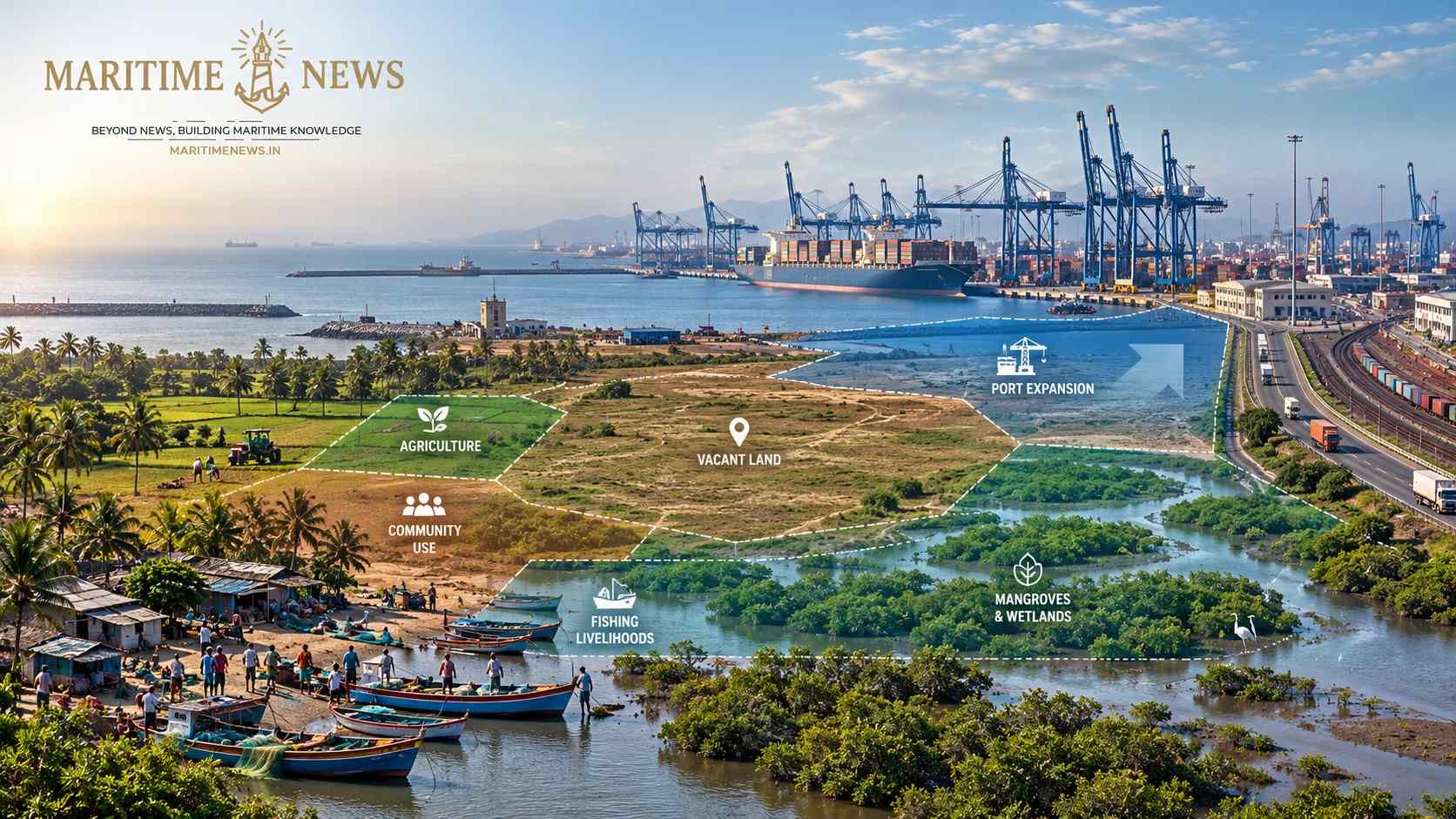
Sonowal’s direction to create a comprehensive database of vacant land at Major Ports could strengthen long-term maritime planning — but “vacant” must not automatically become “available” for development without mapping ownership, statutory restrictions, communities, livelihoods and ecological value
Make us preferred source on Google
Key Takeaways
- The Government is moving towards a comprehensive database of vacant land available at Major Ports to support future expansion.
- Vacant land is not necessarily the same as available, development-ready or legally transferable land.
- Any database should identify ownership, statutory control, existing rights, land-use restrictions and environmental constraints.
- Fishing communities, farmers, tribal communities, local residents and traditional users must be visible in the planning process.
- Mangroves, wetlands, mudflats, marshy areas, creeks, intertidal zones and other coastal ecosystems cannot be treated simply as vacant parcels.
- Land belonging to Forest Departments, Gram Panchayats, Revenue authorities, Railways, Defence or other government agencies requires separate legal and administrative treatment.
- The experience of projects around JNPA/Uran and Vadhavan demonstrates why land availability and community impact must be examined together.
- Compensation alone cannot be treated as the complete measure of justice where livelihoods, access, rehabilitation or traditional rights are affected.
- The ultimate test of the database should be whether it enables faster development without sacrificing due process and the rights of the last affected person.
Also Read: India–MERCOSUR Trade Talks Open as South American Cargo Opportunity Expands
New Delhi, India September 14, 2026 (Maritime News): India’s major ports are entering a period in which land availability could become increasingly important to the country’s maritime expansion.
Future requirements may include port expansion, logistics parks, warehousing, multimodal connectivity, shipbuilding and repair, green-energy infrastructure, industrial facilities and other port-led development.
Against this background, Union Minister for Ports, Shipping & Waterways Shri Sarbananda Sonowal has directed officials to develop a comprehensive database of vacant land at Major Ports, with the objective of ensuring that adequate land is available for future expansion without land constraints.
The direction came during a review of key reforms, flagship initiatives and ongoing programmes in India’s maritime sector.
In his official LinkedIn communication, Sonowal said that, along with Union Minister of State Shri Shantanu Thakur, he reviewed reforms and flagship initiatives aimed at strengthening the maritime sector, with a focus on indigenous shipbuilding, maritime infrastructure, global competitiveness and empowering coastal and riverine communities. Official LinkedIn post by Shri Sarbananda Sonowal
The reported land-database direction therefore comes at a significant moment for India’s port-led development strategy.
But there is one important distinction that needs to remain at the centre of the exercise:
Vacant land is not automatically available land.
And available land is not automatically development-ready land.
Vacant Does Not Mean Available
A parcel can appear vacant on a physical inspection or administrative map while being subject to ownership, statutory, environmental, community or livelihood-related restrictions.
A meaningful national database should therefore go considerably beyond a simple calculation of acreage.
For every parcel, it should establish:
- Who owns the land?
- Who controls it?
- Is it already allotted or encumbered?
- Is it government land?
- Is it private land?
- Is it Gram Panchayat land?
- Is it Forest Department land?
- Is it Revenue Department land?
- Is it Railway or Defence land?
- Are there existing leases, licences or rights?
- Are there traditional livelihood uses?
- Is the land within a CRZ category?
- Does it contain mangroves, wetlands, mudflats or other sensitive ecosystems?
- Is acquisition required?
- Is rehabilitation and resettlement potentially involved?
- Are there fishing or access rights?
- Is there any litigation?
- Is environmental clearance required?
- Is the land actually connected to road, rail, utilities and port infrastructure?
Only after these questions are answered can a parcel meaningfully be classified as development-ready.
The People Who May Not Appear on a Land Map
One of the biggest challenges in port land planning is that a conventional land database records property, while livelihoods may exist beyond formal ownership records.
A fisherman may depend on a creek.
A fishing family may use an intertidal area for access.
A farmer may cultivate land without being the formal owner in the manner reflected in a simple administrative database.
Workers may depend upon a traditional economic activity associated with a particular location.
Communities may have social, cultural or access relationships with land and water that are not adequately represented by a vacant-land column.
This is why a port-land database should not merely answer:
“How many acres are vacant?”
It should also answer:
“Who depends on these acres and the surrounding land and water systems?”
Also Read: Hormuz Crisis Reshapes Gulf Shipping: What It Means for Indian Trade, Freight and Seafarers
Fishing Communities Must Be Mapped Alongside Port Land
This becomes especially important because the Government’s own communication on the maritime-sector review emphasises the empowerment of coastal and riverine communities. Sonowal’s official LinkedIn communication
For fishing communities, the relevant resource may not be the land parcel itself.
It may be:
- a fishing creek;
- a landing point;
- an intertidal area;
- a mudflat;
- a traditional route to the sea;
- fish-drying space;
- boat-storage space;
- access to a jetty;
- breeding grounds;
- tidal water channels.
Consequently, a land database that records only vacant acreage could provide an incomplete picture of the actual development environment.
Farmers and Agricultural Land Cannot Be Reduced to “Vacant”
The same principle applies to agriculture.
A piece of land that is temporarily uncultivated may appear vacant during a particular survey period.
That does not necessarily mean that it has no agricultural value.
Before classifying land as suitable for port expansion or allied development, the assessment should establish:
- prgquisition implications.
The distinction between physically vacant and economically unused is therefore important.
Government Land Is Not One Single Category
Another critical element is ownership.
Government-controlled land can fall under different authorities and legal regimes.
A database should clearly distinguish land under:
- Major Port authorities;
- State Revenue Departments;
- Forest Departments;
- Gram Panchayats;
- Railways;
- Defence authorities;
- other Central Government departments;
- State Government agencies;
- local bodies.
A port cannot necessarily treat every parcel that appears administratively “vacant” as immediately available for its own expansion.
The question is not simply whether land exists.
The question is whether that land can legally and responsibly be used for the proposed purpose.
What About CRZ, Mangroves, Wetlands and Mudflats?
For India’s coastal ports, the environmental layer may be just as important as the land-ownership layer.
A vacant-looking coastal parcel may be associated with:
- mangroves;
- mudflats;
- marshy areas;
- wetlands;
- creeks;
- estuaries;
- intertidal areas;
- flood-prone areas;
- coastal habitats;
- fisheries resources.
These are not empty spaces merely because there is no building on them.
A proper database should therefore integrate land records with environmental and coastal-zone information.
The distinction is fundamental:
No building does not mean no ecological value.
JNPA/Uran Shows Why Land and Livelihood Cannot Be Separated
The history of land acquisition associated with the development of Jawaharlal Nehru Port provides an important reference point.
A 2026 Bombay High Court judgment records that land for the JNPA project in 1984 was obtained from 12 villages in Uran, involving a total area of about 2,933.39 hectares, including private, salt-pan and government land.
The judgment records that affected people included artisans, agricultural labourers, fishermen and salt-pan workers, while fishing, salt cultivation and agriculture were among the major livelihoods in the area. It also discusses the coastal setting involving creeks, estuaries, mudbanks and mudflats. Bombay High Court case record — JNPA/Uran
The case record also refers to concerns raised regarding fisheries, intertidal areas, tidal flows, mangroves and fish breeding, as well as issues raised during the environmental-clearance and public-hearing process.
This should not be read as an argument against port development.
It is instead a reminder that port development and community/environmental planning cannot be treated as two separate exercises.
Rehabilitation Is Part of the Development Question
The human consequences of large port projects can extend for decades.
In 2021, The Indian Express reported that project-affected people from Sheva had sought rehabilitation, with villagers alleging that some families had remained in transit camps for decades following the port-related land acquisition. The report referred to 256 affected families, including agricultural and non-agricultural families. The Indian Express report on Sheva rehabilitation
Whether in an old project or a new one, the lesson is important.
A land database should ideally identify not only whether acquisition is required but also whether the parcel has a history of unresolved rehabilitation or resettlement issues.
Vadhavan Demonstrates the Contemporary Challenge
The proposed Vadhavan Port in Maharashtra provides a more recent example of the complexity surrounding large-scale port development.
In February 2026, The Indian Express reported that compensation processes had moved forward for land acquisition involving villages associated with the Vadhavan project. The Indian Express — Vadhavan compensation report
Earlier, Hindustan Times reported protests involving fisherfolk, farmers and residents in Palghar, with concerns raised over land acquisition, agriculture, forests, villages and coastal ecology. Hindustan Times — Vadhavan protest report
The project’s environmental documentation itself provides for socioeconomic assessment, skill development and measures concerning fisherfolk, including a compensation policy and committee.
The point is not whether development should happen.
The point is whether the development database and acquisition process are comprehensive enough to identify every affected interest before the project advances.
Land Acquisition Must Remain a Separate Legal Question
There is also a crucial distinction between port-owned vacant land and land that must be acquired.
If a parcel is genuinely available within the legal control of a Major Port, its development pathway may be substantially different from privately owned agricultural land or community-dependent land.
The Right to Fair Compensation and Transparency in Land Acquisition, Rehabilitation and Resettlement Act, 2013 establishes a framework centred on humane, participative, informed and transparent acquisition, fair compensation and rehabilitation and resettlement.
India Code — RFCTLARR Act, 2013
Therefore, a vacant-land database should make it immediately clear whether a parcel is:
Port-controlled → Available → Development-ready
or:
Third-party controlled → Requires transfer/allocation
or:
Private/community-dependent → Acquisition potentially required
or:
Environmentally/statutorily restricted → Development constraints
Those categories should never be collapsed into one word: vacant.
Also Read: India Moves to Build a Global Hub for Ship Ownership, Leasing and Maritime Finance Through GIFT City
Development Must Not Become a Race to Acquire Land
India needs land for maritime infrastructure.
There is no question that ports require long-term planning, especially as the country seeks to expand shipping, logistics, shipbuilding, multimodal connectivity, green-energy infrastructure and port-led industrialisation.
But the existence of a vacant-land database should not inadvertently create an administrative culture in which land is considered merely an input to be secured before questions of rights and suitability are fully examined.
The safeguards should ensure that acquisition remains governed by applicable land, environmental, rehabilitation and resettlement laws, with proper public participation and due process.
The database should make development easier where land is genuinely available — not make acquisition easier merely because land has been labelled vacant.
The Last Affected Person Must Not Disappear From the Database
There is a tendency in large infrastructure projects to measure success through:
- hectares acquired;
- investment committed;
- project cost;
- construction progress;
- cargo capacity;
- employment potential;
- commissioning dates.
All are important.
But another question is equally important:
What happened to the last person affected by the project?
Was the person recognised?
Was the livelihood identified?
Was due process followed?
Was compensation paid where applicable?
Was rehabilitation completed?
Was access restored?
Was livelihood restoration addressed?
Was a grievance mechanism available?
Was an appeal possible?
Was the person actually able to rebuild a secure livelihood?
A project should not be considered socially complete merely because compensation has been disbursed.
Also Read: Cochin Shipyard and Drydocks World Sign 50:50 JV to Build India’s Global Ship Repair Ambition
The Database Should Become a People–Land–Nature Map
A genuinely useful national Major Ports land database could therefore have at least three interconnected layers.
Layer 1 — Land
- area;
- ownership;
- possession;
- present use;
- legal status;
- encumbrances;
- lease/allotment;
- government department;
- litigation;
- development potential.
Layer 2 — People
- villages;
- landowners;
- farmers;
- agricultural workers;
- fishing communities;
- fish workers;
- tribal communities;
- traditional users;
- local businesses;
- access routes;
- livelihood dependence;
- previous project-affected families;
- rehabilitation status.
Layer 3 — Nature
- CRZ classification;
- mangroves;
- wetlands;
- mudflats;
- marshes;
- creeks;
- estuaries;
- intertidal areas;
- biodiversity;
- flood vulnerability;
- fisheries habitat;
- environmental clearances and restrictions.
Only when these three layers are brought together can the Government know whether a particular parcel is truly suitable for future maritime development.
The EXIM and Logistics Chain Also Needs to Be Considered
The land question is not limited to port authorities and local communities.
Any expansion of port land will eventually affect the wider maritime logistics chain.
That includes:
- Importers and exporters, who need reliable cargo movement and predictable logistics costs;
- Customs Brokers/Custom House Agents, who depend upon efficient documentation, examination and clearance systems;
- Freight forwarders, who coordinate international cargo movements;
- Logistics service providers, who connect ports with inland markets;
- shipping lines;
- terminal operators;
- CFSs and ICDs;
- truck operators;
- rail logistics;
- warehouse operators;
- port and logistics workers.
A land parcel may therefore be physically adjacent to a port but still have limited value unless its road, rail, warehousing, customs and logistics connectivity is viable.
The database should ultimately help answer not only “Where is land?”, but:
“What maritime economic function can this land sustainably support?”
Accountability Should Begin Before the Land Is Used
The Government has emphasised outcome-driven governance in its broader maritime-sector review. Official LinkedIn communication of Shri Sarbananda Sonowal
The vacant-land initiative provides an opportunity to apply that principle at the land-planning stage itself.
For every identified parcel, the Government could eventually track:
| Question | Accountability measure |
|---|---|
| How much land is vacant? | Verified acreage |
| Who owns it? | Ownership/control record |
| Is it legally available? | Legal-status verification |
| Is development permitted? | Statutory/environmental assessment |
| Who depends on it? | Livelihood and stakeholder mapping |
| Is acquisition required? | Acquisition classification |
| Is R&R required? | R&R assessment |
| What is the intended use? | Project/use classification |
| What is the deadline? | Target date |
| Who is responsible? | Named authority |
| What happened? | Annual outcome audit |
That would transform a simple land inventory into a national maritime development-planning instrument.
MaritimeNews Insight
India needs to plan port land before port expansion becomes constrained by land availability.
But the most useful land database will not be the one that produces the largest number of “vacant acres.”
It will be the one that produces the clearest picture of what can actually be developed, where, under what law, at what cost, with what infrastructure, and with what consequences for people and nature.
The distinction between vacant, available, development-ready and developable should therefore become fundamental to India’s maritime planning vocabulary.
A farmer’s field cannot become “vacant” simply because a future project has identified it.
A fishing ground cannot become “vacant” because it has no permanent structure.
A mangrove or wetland cannot become “vacant” because it has no building.
And land controlled by another government authority cannot become port land merely because it is geographically close to a Major Port.
India’s maritime transformation can be faster and fairer if the two objectives are planned together.
Way Forward
The proposed database should ultimately become more than an inventory of unused land.
It should become a National Major Port Land Intelligence System, integrating:
- Land ownership and control;
- Existing allotments and leases;
- Legal encumbrances;
- Environmental and CRZ layers;
- Community and livelihood mapping;
- Fishing and agricultural dependence;
- Tribal and traditional-user interests;
- Government-agency land;
- Acquisition requirements;
- Rehabilitation and resettlement status;
- Road and rail connectivity;
- Customs and logistics infrastructure;
- Development potential;
- Proposed project use;
- Time-bound accountability.
Such a system could help India identify genuinely development-ready land much faster while reducing the possibility that critical social and environmental questions emerge only after a project has already advanced.
Also Read: Mormugao Port: From Iron-Ore Gateway to Multi-Commodity Port
India’s ports need land.
India’s maritime ambitions also need speed.
But speed in infrastructure development should come from better information and better planning, not from treating every apparently vacant parcel as an uncomplicated development opportunity.
The Government’s move to create a comprehensive database of vacant land at Major Ports can become an important planning reform.
Its real value, however, will depend on what the database sees.
If it sees only acres, it will be a land register.
If it sees land, people, rights, livelihoods, law, infrastructure and nature together, it can become a genuine maritime development intelligence system.
And ultimately, the strongest measure of India’s maritime transformation will not simply be how much port capacity is created.
It will also be whether the country can create that capacity without leaving the last affected person, the last fishing community, the last farmer or the last coastal ecosystem outside the map.
Also Read: Kottayam Port Begins First Container Movement to Vizhinjam, Opening New Kerala EXIM Route
Sources
The article’s principal ministerial reference is the official LinkedIn communication of Union Minister Shri Sarbananda Sonowal. Official LinkedIn post — Shri Sarbananda Sonowal
The JNPA/Uran land and livelihood discussion is based on the Bombay High Court case record. Bombay High Court — JNPA/Uran case
The Sheva rehabilitation reference is based on the report published by The Indian Express. The Indian Express — Sheva rehabilitation
The contemporary Vadhavan references are based on reporting by The Indian Express and Hindustan Times. The Indian Express — Vadhavan compensation Hindustan Times — Vadhavan land and community concerns
The legal framework for land acquisition, rehabilitation and resettlement is the Right to Fair Compensation and Transparency in Land Acquisition, Rehabilitation and Resettlement Act, 2013. India Code — RFCTLARR Act, 2013
Make us preferred source on Google
Reporting by MaritimeNews Bureaus, Writing and Editing by Jaspal Singh Naol.
Major Ports, Port Land Database, Maritime Infrastructure, Coastal Communities, Port-led Development
2 thoughts on “Before India Maps “Vacant” Port Land, Who Will Map the People, Rights and Nature on It?”